
Reporter Dai Chunchen Intern Yang Ruiqing reported from Shenzhen and Guangzhou
Reading
The positioning accuracy from the meter level to the sub-meter level will also trigger the Beidou to infiltrate the business transformation of all walks of life. The positioning of the sub-meters means that the navigators that cannot recognize the road can clearly distinguish the lanes; it means that the shared bicycles that are parked randomly are put into the existing technological basis of the “electronic fenceâ€; this means that the drones perform in a formation. No collision due to positioning errors.
In this era, people have a higher and higher pursuit of the quality of life. The progress of science and technology has brought more beautiful experiences to people in the city. Mobile payment, shared bicycles, drone delivery, and the new economic model driven by big data are being integrated into the daily life of the city, and people's lives have become more and more “intelligentâ€.
In recent years, at least 400 cities in China have proposed the vision of building smart cities. The “energy†on which smart cities operate is ubiquitous, massive data. Most of the data contains at least two coordinates - time and space. The demand for time and space big data tests the strength of the super-engine Beidou satellite navigation system.
In the next three or four months, China will launch four "Beidou III" satellites to open the global networking era of the Beidou satellite navigation system.
"Beidou III" will take the lead in serving services along the "One Belt and One Road" in 2018 and will cover the entire world by 2020. Compared to the "Beidou II" project completed five years ago, "Beidou III" covers a wider area, positioning accuracy is higher, and service quality is better. Twenty or thirty navigation satellites in space will be combined with thousands of ground-enhanced base stations to form a "Tian Luo network" of global space-time big data. This super network will form the nerve center of the "urban brain."
It took nearly 20 years for the United States to make GPS services more than half the planet. In recent years, the service of the Beidou system has quietly entered the civilian fields of transportation, municipal engineering, and security monitoring, and it has maintained the operation of city life.
What combination of "Beidou + Smart City" will have in the future?
Time and space big data "networking"
In 2008, IBM proposed the concept of “Smart Earth†in New York, and it is expected that all things in the human society will be integrated into the Internet, enabling humans to manage production and life in a fine and dynamic manner. This process is like managing the data in your computer. This idea then spawned a worldwide boom of smart city construction. Since 2013, the Chinese government has approved three batches of national smart cities. With the planning of local levels, at least 400 cities in China have proposed the plans and visions of smart cities.
Yang Yuanxi, academician of the Chinese Academy of Engineering, understands that a smart city is based on a unified space-time benchmark that equips sensors to various objects in urban life and integrates the Internet of Things through supercomputers and cloud computing.
China has reasons to promote the construction of smart cities on a large scale. As the economy enters a new normal, China needs to improve the operating efficiency of the city in order to promote the transformation of the industry, especially the tertiary industry. On the other hand, it needs to provide more new services and services to meet the needs of the middle class. Consumption upgrade needs. Emerging industries such as big data and cloud computing that have demonstrated remarkable performance in recent years just provide “intelligent†technical support. In 2012, the Beidou system covering the Asia-Pacific region was responsible for supplying “intelligent†data materials.
The formula of Li Deren, an academician of the two academies, is simple and clear: Smart City = Spatio-Temporal Information + Big Data + Cloud Computing. This means that with the combination of BeiDou and big data and cloud computing technology, a wonderful chemical reaction can take place.
Luo Jin is one of the operators of this chemical reaction. As the general manager of Beijing Beikong Jingao Construction Co., Ltd., he achieved the goal of building a "smart venue." The "Beijing Olympics" in the company's name indicates that they are the operators of the Beijing 2020 Winter Olympic Games venues.
The starting point of “wisdom†is to build a “digital venue†in the cloud. Relying on the space-time coordinate information provided by the National Beidou Precision Service Network, the engineers “restore†ground facilities and underground pipelines in the event area on the computer to establish geographical information systems (GIS) and building information models (BIM) in the event areas. The "digital venues" and the completed physical venues will be in one-to-one correspondence. People and objects in physical venues can be converted into coordinates and parameters in "digital venues." After the Winter Olympics was held, both the audience and the vehicle could upload the real-time space-time coordinate information to the cloud through the mobile terminal; and equipped with the smart light pole of the Beidou navigation chip, it could also capture and monitor nearby vehicles and people flow information, thereby enriching the cloud data and making It is close to reality.
This is the key to the operation of a smart city - transforming all people and things in the city into data, forming a network that is as sophisticated as a nervous system, and incorporating it into an intelligent computer control system. With abundant data, computer cloud computing technology can more accurately maintain the operation of stadiums and events.
On September 17, Luo Jin told reporters that the “smart venues†can meet the needs of precision navigation, personnel management, and item management. For example, in conjunction with the Beidou integrated indoor and outdoor precise positioning, it provides viewers and sports enthusiasts with smart navigation and guidance based on parking spaces, seats, public service facilities, businesses, emergency facilities, and passages in the seating area; As for the delineation of electronic fences, safety protection for the audience and staff is provided around the venue and the area around the stadium. When the security activities are exceeded, on-site and back-office alarms are provided to prevent the occurrence of dangerous viewing competitions.
Not only that, "Smart Stadium" can also meet people's individual needs. For example, according to the historical location of the audience and the actual location, push targeted, personalized new shopping guide information, and marketing information such as offers and group purchases to potential customers.
It is worth noting that Winter Olympics outdoor fields are mostly mountainous areas and are potential threats to landslides and other geological disasters. Through the precision service of BeiDou and the combination of various Sensor data, the “Smart Stadium†can realize the safety monitoring of millimeter-level mountains and building structures.
This kind of experiment is necessary. The Winter Olympic venues are both venues for sporting events and cover all aspects of urban life and can be viewed as a slightly reduced version of “city.†Behind the "smart winter Olympics" is a comprehensive assessment of the construction of smart cities in China.
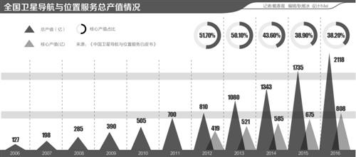
It is worth noting that the Beidou application case described by the “smart venue†has already taken place in China’s reality. The National Beidou Precision Service Network relied on by the “Smart Stadium†has so far entered more than 400 cities nationwide and has been widely used in such fields as urban gas, urban heating, power grid, water supply and drainage, intelligent transportation, and smart pension. Statistics show that in 2006, the total output value of China's satellite navigation and location service industries was only 12.6 billion yuan, which reached 211.8 billion yuan in 2016, an increase of approximately 22.06% over 2015. Among them, Beidou's contribution rate to the industry's core output value has reached 70%, showing remarkable performance.
The “Satellite Navigation Market Report 2017†published by the European Galileo Authority in May of this year believes that emerging technology paradigms such as the Internet of Things or smart cities will link together the formed satellite navigation market segments and create opportunities for hybrid and cross-application applications. The window will generate new user needs and requirements.
Sub-meter precision triggers new business
The US GPS experienced nearly 20 years of market experience before it captured the hearts of Chinese consumers. Today, GPS positioning and navigation services have been able to cope with most of the urban life scenes. However, when your car enters the Guangzhou Tianhe CBD with high-rise buildings, or passes over the complicated overpass of Beijing Xizhimen, the positioning accuracy of GPS will be greatly reduced. Signals such as “Weak GPS Signalâ€, “You Have Yawedâ€, “Please Drive to Open Area†are often heard from the map software. In urban daily life, such embarrassing scenes often appear.
To make urban life better, we must improve the accuracy of positioning and bid farewell to "inaccurate positioning." This is a good show for the BeiDou system. In 2016, with the launch of two on-orbit backup satellites, the civil positioning accuracy of the Beidou system was reduced from less than 10 meters to less than 8 meters.
At the beginning of its design, Beidou III will focus on design targets for the third-generation GPS navigation satellites and Galileo navigation systems that have not yet been launched. "Beidou-3" satellites can use inter-satellite links to achieve mutual communication and data transmission, and can also distance each other to automatically "keep the formation." After the global networking, the positioning accuracy of the Beidou system will be optimized to 2 meters or even 1 meter.
This is only the contribution of the heavenly Beidou satellites (currently 15 in orbit). With the help of ground base stations and reference stations, Beidou satellite can effectively achieve positioning accuracy of decimeter level or millimeter level. Satellite signals naturally have different degrees of delay and error in the transmission process. By setting up the ground enhancement base station, part of the errors can be eliminated to achieve high accuracy.
In recent years, more than 20 Beidou satellites have been sent to space, and over 2,000 ground reference stations have entered many cities across the country. Taking the capital Beijing as an example, the city has completed the construction of 22 Beidou satellite positioning service reference stations (CORS). The completed Beidou CORS system will provide nationwide meter-level positioning enhancement services and centimeter-level high-precision enhancement services covering Beijing.
Just as location services trigger change from scratch, positioning accuracy ranges from meters to sub-meters, and Beidou's penetration into all walks of life will trigger business transformation. The positioning of the sub-meters means that the navigators that cannot recognize the road can clearly distinguish the lanes; it means that the shared bicycles that are parked randomly are put into the existing technological basis of the “electronic fenceâ€; this means that the drones perform in a formation. No collision due to positioning errors.
While improving the original new business experience, high precision has also spawned many new markets. The scenes of guarding the city's safety such as gas pipeline inspection, power maintenance, and mountain safety monitoring all rely on Beidou's high-precision positioning.
The first time I saw the power of Beidou's high precision, Zhang Lin, manager of Shenzhen Gas Group, was surprised. The various municipal pipelines that are densely covered under the ground, like the capillaries of each city, are not easy to maintain. The gas pipeline is too thin, and the previous satellite navigation system could not be clearly identified.
“In the past, the workers’ masters went out to inspect and saw where the leakage was based on experience alone. The locations where the leaks were encountered were also observed by maintenance personnel. It was difficult to find the exact location of the leak once they were gone.†Zhang Lin at 9 On the 17th of this month, he told reporters: "Now, data analysis can quickly analyze the location of leaks. After passing the location, it can be overhauled."
Similar cases also appear in power overhauls. According to Li Chaoyang, deputy chief engineer of the State Grid Information and Communication Industry Group, the State Grid is using power-based ground enhancement technology to correct satellite parameters and improve positioning accuracy. At the same time, Beidou's unique "short message" function enables national grid monitoring. Instantly transmit monitoring data at a time without worrying about poor communication in remote mountainous areas, thereby safeguarding the city's energy security.
On September 26, Hua Zhongxiong, director of the Center for Space-time Information Engineering of Hubei Smart City, mentioned that with the rapid development of China's Beidou technology, the cost of Beidou’s high-precision applications is rapidly decreasing. Before 2016, the terminal for differential positioning of centimeter-grade foundations had an annual service fee of 8,000-9,000 yuan; this figure has been lowered to 3,000-4,000 yuan in 2017. This will greatly promote the in-depth penetration of Beidou in all walks of life.
However, Xing Jianping, School of Information Technology and Engineering of Shandong University, also warned companies that they should not only focus on chip development, nor should they engage in the Beidou on Beidou. The real application of the industry requires temperature, humidity, video, and other information. The chip's high-precision algorithms must fall into specific application areas. The Beidou technology must be closely integrated with the Internet of Things, car networking, and intelligent sensing industries to reduce risks. .
"Standard" global market
The “Smart Earth†put forward by IBM is not limited to one country, one domain. Can China's "Beidou + Smart City" be replicated and promoted to overseas countries so as to truly build a "Smart World"? To realize this idea, we must first realize the internationalization of the BeiDou standard. Just like the socket interfaces of different countries and regions are different, BeiDou products must have the linkage with the global market to realize the “standard†global market. Conversion head."
On September 5, China issued the "Beidou Satellite Navigation System Spatial Signal Interface Control Document Open Service Signals B1C, B2a (Beta)". Prior to this, China successively issued the Beidou System Open Multifunctional Specification (Version 1.0) and the Beidou Satellite Navigation System Spatial Signal Interface Control Document (Version 2.0), which includes the Beidou System's second civil signal, B2I. (B1C, B2a, and B2I all represent a frequency coding.) This time, the B1C and B2a service signals correspond to two frequency points, and they are also GPS, GLONASS, Galileo, and other global satellite navigation system civil interoperability center frequencies. Based on the open signal interface control data, domestic and foreign companies can develop high-precision receivers compatible with other satellite navigation systems such as Beidou, GPS, and GLONASS.
In fact, when people talk about Beidou's high-precision applications, it is not about the high precision achieved by the BeiDou system. At the same time, the Beidou system has also chosen to explore compatibility with GPS and GLONASS systems, and to achieve a higher degree of precision in a shared and shared attitude. This is not only the Beidou system's response to GPS and GLONASS' entry into the Chinese market, but also an important strategy for the Beidou system to “go globalâ€.
There are many similar international cooperation cases. From the beginning of August, experts from China and Russia conducted joint on-orbit experiments on navigation satellites of the two countries, and spent two weeks studying and evaluating the navigation conditions of the Beidou and GLONASS systems along the “Silk Road Economic Beltâ€. Compatible and interoperable.
Industry sources told reporters that the Sino-Russian joint experiment was very successful. Starting from the ancient Silk Road in the northwest, the accuracy of Beidou and GLONASS compatible terminals was stable at 1-2 meters, and the quality was very high.
This looting of documents published before the launch of the "Beidou III" was of great significance. Cao Chong, chief expert of the China Satellite Navigation Association, understands that the issuance of this new document is "a major step for the Beidou system to truly move toward globalization."
In Cao Chong’s view, China has the largest consumer market in the world. Currently, global smart phone and navigation and positioning chip manufacturers all set the BeiDou function as a mandatory function of their products. Only by promoting the compatibility and interoperability of BeiDou and other satellite navigation systems, can more manufacturers attract the BeiDou function as the standard configuration of the products, thereby promoting China's BeiDou products to become global.
According to Cao Chong, Beidou's standardization of interoperability and interoperability will be fully promoted. Nearly 100% of the domestic market coverage will be achieved by 2020, with sales of smart mobile terminals containing BeiDou functions approaching 500 million units, and social holdings reaching nearly 1.4 billion units. China’s navigation and positioning market has become the world’s largest user group, with an output value of 400 billion yuan, accounting for around 20% of the world’s share.
Hua Zhongxiong stated that the issuance of new documents will promote the opening up of the civilian field of the Beidou and attract more companies and talents, especially overseas companies and talents, into the Beidou application development field, thereby expanding the industry scale.
“Foreign companies have an urgent need for the Beidou high-precision service.†Hua Zhongxiu told the 21st Century Business Herald reporter. He also engaged in the operation of smart city enterprises and visited Iran two or three years ago. Local enterprises are very interested in Beidou, and have combined his company to form the Beidou Hi-tech Industrial Park in Iran.
This open posture is actually a strategy adopted by the GPS system into the Chinese market that year. In the ringing of GPS, GLONASS, etc., the opening of the Beidou system means linking the “Chinese standard†with advanced “international standardsâ€.
However, the actual docking of "international standards" is not as easy as in China. Foreign policy environments and cultural environments are different from domestic ones. For example, the problem of high-precision ground reference station construction.
"Some lands are privately owned. Some governments will suffer from some obstacles to the construction of overseas ground reference stations for the sake of safety and security. All these need to be solved by the game." Hua Zhongxiong said.
Relying on accredited international standards, Chinese motorcycle companies are planning to install Beidou chips standard before the end of 2018 and export them to overseas markets. It is estimated that the export will exceed 10 million units annually.

Incremental Encoder,Linear Scale Encoder,Dual Concentric Rotary Encoder,Dc Servo Motor Encoder
Yuheng Optics Co., Ltd.(Changchun) , https://www.yhencoder.com